|
|
|||||||||||||||||
| Point ID: 6928 | Downloads | Plots | Site Data | Code: 10593 |
|
|
|||||||||||||||||
| Download | |
|---|---|
| Site Descriptor Information | Site Time Series Data |
| Link to all available data | |
| View: | Time Series | All |
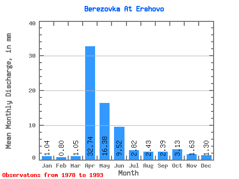
| Units: | m3/s |
| Statistic | Jan | Feb | Mar | Apr | May | Jun | Jul | Aug | Sep | Oct | Nov | Dec | Annual |
|---|---|---|---|---|---|---|---|---|---|---|---|---|---|
| Mean | 1.04 | 0.81 | 1.05 | 32.74 | 16.38 | 9.52 | 2.82 | 2.43 | 2.39 | 3.13 | 1.64 | 1.30 | 75.48 |
| Standard Deviation | 0.38 | 0.26 | 0.60 | 16.36 | 10.65 | 19.94 | 2.49 | 1.58 | 1.33 | 1.70 | 0.46 | 0.41 | 33.89 |
| Min | 0.62 | 0.39 | 0.33 | 7.19 | 3.21 | 1.05 | 0.89 | 0.93 | 0.90 | 1.08 | 0.82 | 0.73 | 37.55 |
| Max | 2.09 | 1.30 | 2.79 | 66.30 | 40.25 | 75.29 | 9.37 | 5.96 | 4.31 | 6.50 | 2.36 | 2.25 | 165.32 |
| Coefficient of Variation | 0.37 | 0.32 | 0.58 | 0.50 | 0.65 | 2.10 | 0.89 | 0.65 | 0.55 | 0.54 | 0.28 | 0.31 | 0.45 |
 Return to R-Arctic Net Home Page