|
|
|||||||||||||||||
| Point ID: 6923 | Downloads | Plots | Site Data | Code: 10587 |
|
|
|||||||||||||||||
| Download | |
|---|---|
| Site Descriptor Information | Site Time Series Data |
| Link to all available data | |
| View: | Time Series | All |
| Units: | m3/s |
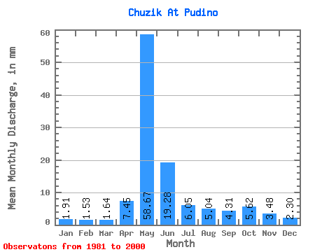
| Statistic | Jan | Feb | Mar | Apr | May | Jun | Jul | Aug | Sep | Oct | Nov | Dec | Annual |
|---|---|---|---|---|---|---|---|---|---|---|---|---|---|
| Mean | 1.91 | 1.54 | 1.64 | 7.45 | 58.66 | 19.28 | 6.05 | 5.04 | 4.31 | 5.62 | 3.48 | 2.30 | 116.43 |
| Standard Deviation | 0.49 | 0.30 | 0.23 | 5.00 | 33.12 | 13.72 | 4.81 | 6.64 | 3.32 | 3.57 | 1.84 | 0.82 | 57.93 |
| Min | 1.27 | 1.10 | 1.37 | 1.92 | 14.89 | 3.23 | 1.84 | 1.67 | 1.89 | 2.28 | 1.44 | 1.35 | 48.72 |
| Max | 3.12 | 2.25 | 2.13 | 17.30 | 126.81 | 60.30 | 19.85 | 28.28 | 12.73 | 13.31 | 7.85 | 4.11 | 279.19 |
| Coefficient of Variation | 0.26 | 0.20 | 0.14 | 0.67 | 0.56 | 0.71 | 0.80 | 1.32 | 0.77 | 0.64 | 0.53 | 0.36 | 0.50 |
 Return to R-Arctic Net Home Page