|
|
|||||||||||||||||
| Point ID: 6921 | Downloads | Plots | Site Data | Code: 10585 |
|
|
|||||||||||||||||
| Download | |
|---|---|
| Site Descriptor Information | Site Time Series Data |
| Link to all available data | |
| View: | Time Series | All |
| Units: | m3/s |
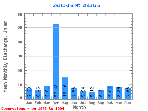
| Statistic | Jan | Feb | Mar | Apr | May | Jun | Jul | Aug | Sep | Oct | Nov | Dec | Annual |
|---|---|---|---|---|---|---|---|---|---|---|---|---|---|
| Mean | 7.33 | 6.51 | 9.01 | 52.42 | 15.15 | 7.56 | 5.94 | 5.12 | 6.21 | 9.04 | 8.29 | 7.66 | 140.84 |
| Standard Deviation | 1.51 | 1.20 | 3.14 | 13.31 | 9.52 | 1.76 | 1.20 | 1.12 | 1.57 | 1.60 | 1.21 | 1.55 | 20.80 |
| Min | 5.00 | 4.42 | 5.86 | 23.36 | 9.14 | 5.46 | 4.21 | 3.07 | 4.49 | 6.57 | 5.67 | 5.14 | 101.06 |
| Max | 10.43 | 9.04 | 18.78 | 78.80 | 48.06 | 12.10 | 8.78 | 7.36 | 10.23 | 10.93 | 10.37 | 10.57 | 185.92 |
| Coefficient of Variation | 0.21 | 0.18 | 0.35 | 0.25 | 0.63 | 0.23 | 0.20 | 0.22 | 0.25 | 0.18 | 0.15 | 0.20 | 0.15 |
 Return to R-Arctic Net Home Page