|
|
|||||||||||||||||
| Point ID: 6917 | Downloads | Plots | Site Data | Code: 10581 |
|
|
|||||||||||||||||
| Download | |
|---|---|
| Site Descriptor Information | Site Time Series Data |
| Link to all available data | |
| View: | Time Series | All |
| Units: | m3/s |
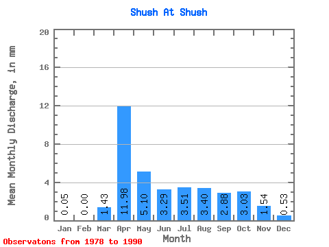
| Statistic | Jan | Feb | Mar | Apr | May | Jun | Jul | Aug | Sep | Oct | Nov | Dec | Annual |
|---|---|---|---|---|---|---|---|---|---|---|---|---|---|
| Mean | 0.07 | 0.00 | 1.42 | 11.99 | 5.08 | 3.30 | 3.50 | 3.42 | 2.88 | 3.01 | 1.57 | 0.51 | 41.64 |
| Standard Deviation | 0.13 | 0.00 | 1.90 | 7.99 | 4.87 | 2.81 | 2.94 | 3.46 | 2.83 | 2.94 | 2.17 | 0.83 | 35.18 |
| Min | 0.00 | 0.00 | 0.00 | 0.62 | 0.21 | 0.00 | 0.00 | 0.00 | 0.00 | 0.00 | 0.00 | 0.00 | 0.89 |
| Max | 0.27 | 0.00 | 5.26 | 28.80 | 12.22 | 7.71 | 8.50 | 11.69 | 8.23 | 10.10 | 6.69 | 1.91 | 78.06 |
| Coefficient of Variation | 2.00 | 1.34 | 0.67 | 0.96 | 0.85 | 0.84 | 1.01 | 0.98 | 0.98 | 1.39 | 1.63 | 0.84 |
 Return to R-Arctic Net Home Page