|
|
|||||||||||||||||
| Point ID: 6909 | Downloads | Plots | Site Data | Code: 10570 |
|
|
|||||||||||||||||
| Download | |
|---|---|
| Site Descriptor Information | Site Time Series Data |
| Link to all available data | |
| View: | Time Series | All |
| Units: | m3/s |
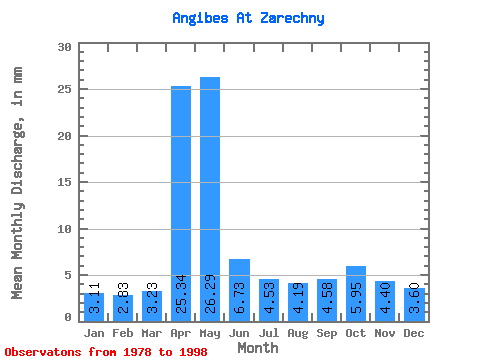
| Statistic | Jan | Feb | Mar | Apr | May | Jun | Jul | Aug | Sep | Oct | Nov | Dec | Annual |
|---|---|---|---|---|---|---|---|---|---|---|---|---|---|
| Mean | 3.11 | 2.85 | 3.23 | 25.34 | 26.28 | 6.73 | 4.53 | 4.19 | 4.58 | 5.95 | 4.40 | 3.60 | 105.36 |
| Standard Deviation | 1.12 | 1.15 | 1.50 | 11.68 | 21.27 | 3.32 | 1.35 | 1.96 | 2.02 | 2.28 | 1.75 | 0.98 | 25.56 |
| Min | 0.41 | 0.37 | 0.44 | 9.24 | 1.49 | 0.16 | 1.31 | 0.02 | 0.01 | 0.88 | 0.99 | 2.07 | 60.98 |
| Max | 4.50 | 4.42 | 5.05 | 47.20 | 71.84 | 11.65 | 6.31 | 8.35 | 8.48 | 10.19 | 8.28 | 4.88 | 156.11 |
| Coefficient of Variation | 0.36 | 0.40 | 0.47 | 0.46 | 0.81 | 0.49 | 0.30 | 0.47 | 0.44 | 0.38 | 0.40 | 0.27 | 0.24 |
 Return to R-Arctic Net Home Page