|
|
|||||||||||||||||
| Point ID: 6906 | Downloads | Plots | Site Data | Code: 10567 |
|
|
|||||||||||||||||
| Download | |
|---|---|
| Site Descriptor Information | Site Time Series Data |
| Link to all available data | |
| View: | Time Series | All |
| Units: | m3/s |
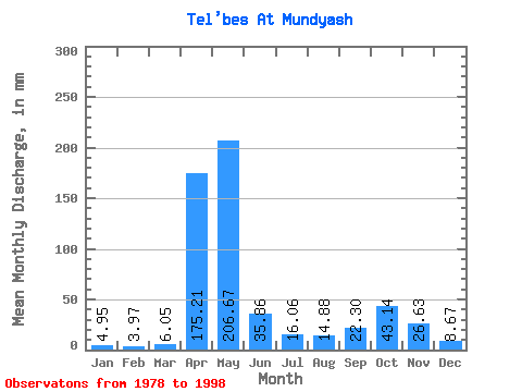
| Statistic | Jan | Feb | Mar | Apr | May | Jun | Jul | Aug | Sep | Oct | Nov | Dec | Annual |
|---|---|---|---|---|---|---|---|---|---|---|---|---|---|
| Mean | 4.95 | 4.01 | 6.05 | 175.21 | 206.64 | 35.87 | 16.05 | 14.88 | 22.30 | 43.13 | 26.63 | 8.67 | 563.13 |
| Standard Deviation | 2.67 | 2.14 | 3.42 | 64.36 | 89.91 | 24.08 | 14.22 | 11.12 | 20.18 | 30.35 | 13.49 | 5.43 | 89.80 |
| Min | 2.81 | 2.12 | 2.54 | 93.10 | 68.73 | 10.28 | 4.69 | 5.74 | 4.54 | 9.24 | 8.75 | 4.02 | 412.82 |
| Max | 12.59 | 8.89 | 12.45 | 302.40 | 412.86 | 97.42 | 65.83 | 45.08 | 74.74 | 111.14 | 60.48 | 25.44 | 722.57 |
| Coefficient of Variation | 0.54 | 0.53 | 0.57 | 0.37 | 0.43 | 0.67 | 0.89 | 0.75 | 0.91 | 0.70 | 0.51 | 0.63 | 0.16 |
 Return to R-Arctic Net Home Page