|
|
|||||||||||||||||
| Point ID: 6905 | Downloads | Plots | Site Data | Code: 10566 |
|
|
|||||||||||||||||
| Download | |
|---|---|
| Site Descriptor Information | Site Time Series Data |
| Link to all available data | |
| View: | Time Series | All |
| Units: | m3/s |
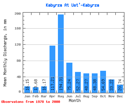
| Statistic | Jan | Feb | Mar | Apr | May | Jun | Jul | Aug | Sep | Oct | Nov | Dec | Annual |
|---|---|---|---|---|---|---|---|---|---|---|---|---|---|
| Mean | 16.14 | 13.79 | 16.17 | 117.21 | 194.28 | 75.24 | 52.27 | 48.26 | 48.38 | 54.69 | 33.22 | 20.74 | 688.27 |
| Standard Deviation | 6.63 | 6.01 | 10.53 | 86.49 | 78.08 | 36.60 | 29.24 | 26.41 | 17.83 | 21.24 | 14.94 | 10.93 | 264.79 |
| Min | 6.23 | 6.35 | 5.92 | 45.31 | 100.37 | 36.67 | 26.34 | 24.17 | 22.34 | 24.39 | 10.14 | 10.82 | 451.82 |
| Max | 31.79 | 25.79 | 48.99 | 423.57 | 455.04 | 194.72 | 140.00 | 132.59 | 90.19 | 97.54 | 62.17 | 45.50 | 1674.43 |
| Coefficient of Variation | 0.41 | 0.44 | 0.65 | 0.74 | 0.40 | 0.49 | 0.56 | 0.55 | 0.37 | 0.39 | 0.45 | 0.53 | 0.39 |
 Return to R-Arctic Net Home Page