|
|
|||||||||||||||||
| Point ID: 6884 | Downloads | Plots | Site Data | Code: 10519 |
|
|
|||||||||||||||||
| Download | |
|---|---|
| Site Descriptor Information | Site Time Series Data |
| Link to all available data | |
| View: | Time Series | All |
| Units: | m3/s |
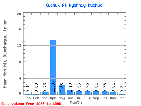
| Statistic | Jan | Feb | Mar | Apr | May | Jun | Jul | Aug | Sep | Oct | Nov | Dec | Annual |
|---|---|---|---|---|---|---|---|---|---|---|---|---|---|
| Mean | 0.11 | 0.09 | 0.73 | 13.37 | 2.38 | 1.10 | 0.96 | 0.90 | 0.81 | 0.96 | 0.61 | 0.24 | 25.63 |
| Standard Deviation | 0.10 | 0.10 | 1.53 | 11.13 | 1.28 | 0.38 | 0.48 | 0.41 | 0.26 | 0.41 | 0.39 | 0.14 | 13.74 |
| Min | 0.00 | 0.00 | 0.01 | 1.83 | 0.78 | 0.57 | 0.54 | 0.49 | 0.47 | 0.49 | 0.16 | 0.04 | 6.83 |
| Max | 0.38 | 0.37 | 6.48 | 58.53 | 6.10 | 2.09 | 3.67 | 2.89 | 2.06 | 2.97 | 2.59 | 0.62 | 69.77 |
| Coefficient of Variation | 0.89 | 1.05 | 2.10 | 0.83 | 0.54 | 0.34 | 0.50 | 0.46 | 0.32 | 0.43 | 0.63 | 0.58 | 0.54 |
 Return to R-Arctic Net Home Page