|
|
|||||||||||||||||
| Point ID: 688 | Downloads | Plots | Site Data | Code: 07CA010 |
|
|
|||||||||||||||||
| Download | |
|---|---|
| Site Descriptor Information | Site Time Series Data |
| Link to all available data | |
| View: | Time Series | All |
| Units: | m3/s |
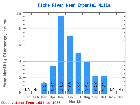
| Statistic | Jan | Feb | Mar | Apr | May | Jun | Jul | Aug | Sep | Oct | Nov | Dec | Annual |
|---|---|---|---|---|---|---|---|---|---|---|---|---|---|
| Mean | 1.23 | 3.31 | 9.17 | 6.78 | 4.79 | 3.76 | 2.12 | 2.12 | |||||
| Standard Deviation | 0.29 | 1.77 | 9.30 | 3.00 | 0.59 | 2.74 | 1.74 | 3.01 | |||||
| Min | 0.97 | 1.74 | 3.22 | 3.45 | 4.13 | 1.81 | 1.01 | 0.15 | |||||
| Max | 1.55 | 5.23 | 19.89 | 9.29 | 5.28 | 6.89 | 4.13 | 5.59 | |||||
| Coefficient of Variation | 0.24 | 0.54 | 1.01 | 0.44 | 0.12 | 0.73 | 0.82 | 1.42 |
 Return to R-Arctic Net Home Page