|
|
|||||||||||||||||
| Point ID: 6879 | Downloads | Plots | Site Data | Other Close Sites | Code: 10505 |
|
|
|||||||||||||||||
| Download | |
|---|---|
| Site Descriptor Information | Site Time Series Data |
| Link to all available data | |
| View: | Time Series | All |
| Units: | m3/s |
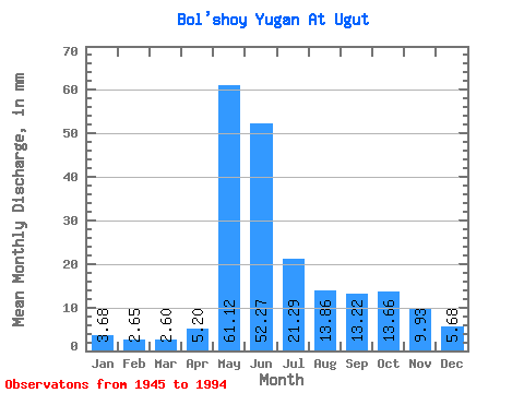
| Statistic | Jan | Feb | Mar | Apr | May | Jun | Jul | Aug | Sep | Oct | Nov | Dec | Annual |
|---|---|---|---|---|---|---|---|---|---|---|---|---|---|
| Mean | 3.67 | 2.67 | 2.60 | 5.20 | 61.11 | 52.27 | 21.29 | 13.85 | 13.22 | 13.65 | 9.93 | 5.68 | 204.34 |
| Standard Deviation | 1.07 | 0.61 | 0.48 | 3.91 | 17.52 | 22.62 | 13.51 | 9.35 | 9.83 | 8.96 | 5.66 | 2.31 | 55.09 |
| Min | 2.11 | 1.81 | 1.62 | 1.72 | 29.93 | 11.63 | 4.98 | 3.49 | 3.03 | 2.71 | 2.83 | 2.23 | 110.95 |
| Max | 6.94 | 4.43 | 3.78 | 21.11 | 110.51 | 100.40 | 71.49 | 40.35 | 38.00 | 36.84 | 22.99 | 10.83 | 352.61 |
| Coefficient of Variation | 0.29 | 0.23 | 0.18 | 0.75 | 0.29 | 0.43 | 0.64 | 0.68 | 0.74 | 0.66 | 0.57 | 0.41 | 0.27 |
| Other Close Sites | ||||||
|---|---|---|---|---|---|---|
| PointID | Latitude | Longitude | Drainage Area | Source | Name | |
| 6878 | "Bo'shoy Yugan At Ruskiny" | 60.27 | -910921 | SHI | 236.00 | |
| 6880 | "Bol'shoy Yugan At Yugan Pzu" | 60.67 | -898935 | SHI | 118.00 | |
 Return to R-Arctic Net Home Page