|
|
|||||||||||||||||
| Point ID: 6853 | Downloads | Plots | Site Data | Code: 10464 |
|
|
|||||||||||||||||
| Download | |
|---|---|
| Site Descriptor Information | Site Time Series Data |
| Link to all available data | |
| View: | Time Series | All |
| Units: | m3/s |
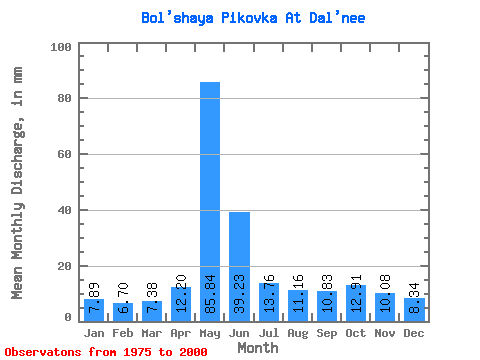
| Statistic | Jan | Feb | Mar | Apr | May | Jun | Jul | Aug | Sep | Oct | Nov | Dec | Annual |
|---|---|---|---|---|---|---|---|---|---|---|---|---|---|
| Mean | 7.89 | 6.76 | 7.38 | 12.20 | 85.83 | 39.23 | 13.75 | 11.16 | 10.83 | 12.91 | 10.08 | 8.34 | 226.67 |
| Standard Deviation | 1.92 | 1.48 | 1.91 | 6.77 | 32.42 | 22.61 | 4.58 | 4.32 | 3.99 | 4.70 | 3.74 | 2.15 | 59.12 |
| Min | 4.58 | 4.37 | 4.94 | 6.65 | 34.52 | 11.58 | 7.38 | 4.76 | 5.36 | 5.45 | 4.18 | 3.93 | 126.42 |
| Max | 13.78 | 9.52 | 11.61 | 30.24 | 135.98 | 84.38 | 22.50 | 21.54 | 19.55 | 20.23 | 17.48 | 13.63 | 329.51 |
| Coefficient of Variation | 0.24 | 0.22 | 0.26 | 0.56 | 0.38 | 0.58 | 0.33 | 0.39 | 0.37 | 0.36 | 0.37 | 0.26 | 0.26 |
 Return to R-Arctic Net Home Page