|
|
|||||||||||||||||
| Point ID: 684 | Downloads | Plots | Site Data | Code: 07CA003 |
|
|
|||||||||||||||||
| Download | |
|---|---|
| Site Descriptor Information | Site Time Series Data |
| Link to all available data | |
| View: | Time Series | All |
| Units: | m3/s |
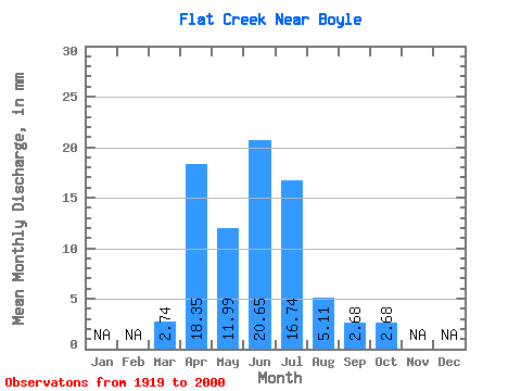
| Statistic | Jan | Feb | Mar | Apr | May | Jun | Jul | Aug | Sep | Oct | Nov | Dec | Annual |
|---|---|---|---|---|---|---|---|---|---|---|---|---|---|
| Mean | 1.31 | 8.77 | 5.73 | 9.87 | 8.01 | 2.44 | 1.28 | 1.29 | |||||
| Standard Deviation | 2.04 | 12.77 | 8.18 | 19.92 | 12.87 | 3.81 | 2.15 | 3.13 | |||||
| Min | 0.00 | 0.00 | 0.00 | 0.00 | 0.00 | 0.00 | 0.00 | 0.00 | |||||
| Max | 6.93 | 63.81 | 31.44 | 99.31 | 50.80 | 15.14 | 10.35 | 17.46 | |||||
| Coefficient of Variation | 1.55 | 1.46 | 1.43 | 2.02 | 1.61 | 1.56 | 1.68 | 2.43 |
 Return to R-Arctic Net Home Page