|
|
|||||||||||||||||
| Point ID: 6822 | Downloads | Plots | Site Data | Code: 10399 |
|
|
|||||||||||||||||
| Download | |
|---|---|
| Site Descriptor Information | Site Time Series Data |
| Link to all available data | |
| View: | Time Series | All |
| Units: | m3/s |
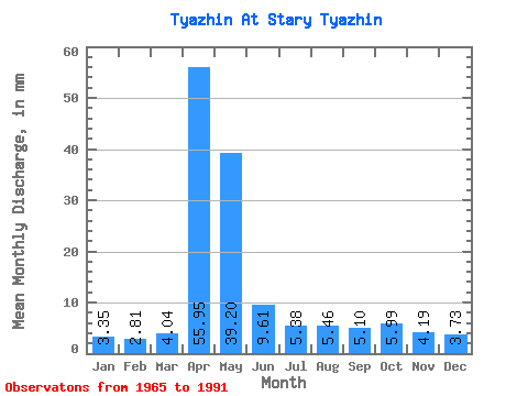
| Statistic | Jan | Feb | Mar | Apr | May | Jun | Jul | Aug | Sep | Oct | Nov | Dec | Annual |
|---|---|---|---|---|---|---|---|---|---|---|---|---|---|
| Mean | 3.35 | 2.83 | 4.04 | 55.95 | 39.19 | 9.61 | 5.38 | 5.46 | 5.10 | 5.99 | 4.19 | 3.73 | 145.59 |
| Standard Deviation | 1.39 | 1.19 | 2.96 | 28.84 | 31.98 | 6.75 | 2.91 | 3.01 | 2.36 | 2.04 | 1.51 | 1.47 | 48.98 |
| Min | 1.24 | 1.23 | 1.16 | 10.14 | 5.68 | 3.33 | 1.97 | 1.93 | 1.94 | 3.29 | 1.68 | 1.51 | 51.16 |
| Max | 6.61 | 6.37 | 16.27 | 128.29 | 133.71 | 36.06 | 14.18 | 12.60 | 11.86 | 11.63 | 7.26 | 7.23 | 273.59 |
| Coefficient of Variation | 0.41 | 0.42 | 0.73 | 0.52 | 0.82 | 0.70 | 0.54 | 0.55 | 0.46 | 0.34 | 0.36 | 0.40 | 0.34 |
 Return to R-Arctic Net Home Page