|
|
|||||||||||||||||
| Point ID: 6818 | Downloads | Plots | Site Data | Code: 10392 |
|
|
|||||||||||||||||
| Download | |
|---|---|
| Site Descriptor Information | Site Time Series Data |
| Link to all available data | |
| View: | Time Series | All |
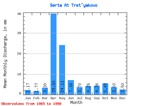
| Units: | m3/s |
| Statistic | Jan | Feb | Mar | Apr | May | Jun | Jul | Aug | Sep | Oct | Nov | Dec | Annual |
|---|---|---|---|---|---|---|---|---|---|---|---|---|---|
| Mean | 2.17 | 1.79 | 3.30 | 39.49 | 24.10 | 7.17 | 3.70 | 4.26 | 4.36 | 5.49 | 3.60 | 2.50 | 103.09 |
| Standard Deviation | 0.91 | 0.82 | 5.20 | 15.87 | 20.26 | 4.44 | 1.81 | 2.46 | 3.89 | 4.63 | 1.79 | 0.99 | 28.28 |
| Min | 0.41 | 0.37 | 0.64 | 8.41 | 5.34 | 2.29 | 1.56 | 1.59 | 1.34 | 1.89 | 1.15 | 0.88 | 55.92 |
| Max | 4.53 | 3.48 | 29.48 | 72.00 | 113.27 | 21.04 | 8.08 | 12.41 | 22.39 | 21.57 | 10.47 | 4.87 | 155.84 |
| Coefficient of Variation | 0.42 | 0.46 | 1.58 | 0.40 | 0.84 | 0.62 | 0.49 | 0.58 | 0.89 | 0.84 | 0.49 | 0.40 | 0.27 |
 Return to R-Arctic Net Home Page