|
|
|||||||||||||||||
| Point ID: 6813 | Downloads | Plots | Site Data | Code: 10383 |
|
|
|||||||||||||||||
| Download | |
|---|---|
| Site Descriptor Information | Site Time Series Data |
| Link to all available data | |
| View: | Time Series | All |
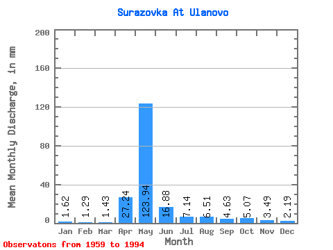
| Units: | m3/s |
| Statistic | Jan | Feb | Mar | Apr | May | Jun | Jul | Aug | Sep | Oct | Nov | Dec | Annual |
|---|---|---|---|---|---|---|---|---|---|---|---|---|---|
| Mean | 1.63 | 1.30 | 1.43 | 27.24 | 123.92 | 16.88 | 7.14 | 6.51 | 4.62 | 5.07 | 3.48 | 2.19 | 199.18 |
| Standard Deviation | 0.71 | 0.54 | 0.57 | 28.22 | 52.60 | 8.43 | 6.86 | 6.76 | 3.60 | 3.17 | 1.68 | 0.93 | 48.35 |
| Min | 0.65 | 0.47 | 0.32 | 0.76 | 37.65 | 5.39 | 2.36 | 0.26 | 1.84 | 1.96 | 1.46 | 0.98 | 99.60 |
| Max | 3.99 | 2.69 | 2.62 | 95.06 | 235.06 | 31.56 | 30.97 | 34.31 | 19.39 | 14.08 | 8.05 | 4.91 | 291.23 |
| Coefficient of Variation | 0.44 | 0.41 | 0.40 | 1.04 | 0.42 | 0.50 | 0.96 | 1.04 | 0.78 | 0.62 | 0.48 | 0.42 | 0.24 |
 Return to R-Arctic Net Home Page