|
|
|||||||||||||||||
| Point ID: 6812 | Downloads | Plots | Site Data | Code: 10382 |
|
|
|||||||||||||||||
| Download | |
|---|---|
| Site Descriptor Information | Site Time Series Data |
| Link to all available data | |
| View: | Time Series | All |
| Units: | m3/s |
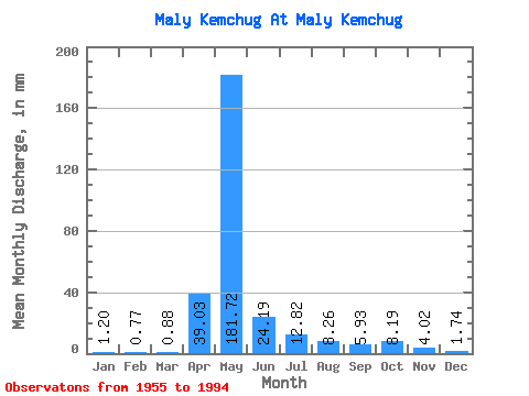
| Statistic | Jan | Feb | Mar | Apr | May | Jun | Jul | Aug | Sep | Oct | Nov | Dec | Annual |
|---|---|---|---|---|---|---|---|---|---|---|---|---|---|
| Mean | 1.20 | 0.78 | 0.88 | 39.03 | 181.70 | 24.19 | 12.82 | 8.26 | 5.93 | 8.19 | 4.03 | 1.73 | 288.68 |
| Standard Deviation | 0.88 | 0.69 | 0.71 | 43.16 | 72.03 | 17.81 | 24.28 | 12.48 | 6.43 | 9.01 | 3.83 | 1.17 | 76.61 |
| Min | 0.18 | 0.11 | 0.02 | 0.27 | 16.82 | 3.73 | 1.18 | 0.49 | 0.69 | 0.73 | 0.69 | 0.43 | 144.58 |
| Max | 4.29 | 3.71 | 2.68 | 137.89 | 289.22 | 87.40 | 143.54 | 52.70 | 23.43 | 47.78 | 18.66 | 5.04 | 459.44 |
| Coefficient of Variation | 0.73 | 0.88 | 0.80 | 1.11 | 0.40 | 0.74 | 1.89 | 1.51 | 1.08 | 1.10 | 0.95 | 0.67 | 0.27 |
 Return to R-Arctic Net Home Page