|
|
|||||||||||||||||
| Point ID: 6810 | Downloads | Plots | Site Data | Code: 10380 |
|
|
|||||||||||||||||
| Download | |
|---|---|
| Site Descriptor Information | Site Time Series Data |
| Link to all available data | |
| View: | Time Series | All |
| Units: | m3/s |
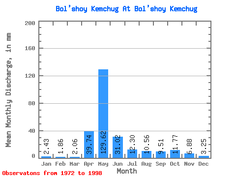
| Statistic | Jan | Feb | Mar | Apr | May | Jun | Jul | Aug | Sep | Oct | Nov | Dec | Annual |
|---|---|---|---|---|---|---|---|---|---|---|---|---|---|
| Mean | 2.43 | 1.88 | 2.06 | 39.74 | 129.60 | 31.02 | 12.30 | 10.55 | 9.51 | 11.77 | 6.88 | 3.25 | 259.32 |
| Standard Deviation | 0.70 | 0.59 | 0.53 | 29.82 | 51.39 | 17.02 | 7.74 | 12.12 | 7.57 | 6.89 | 4.58 | 1.29 | 56.87 |
| Min | 1.47 | 1.15 | 1.21 | 5.57 | 19.90 | 8.02 | 4.60 | 3.09 | 3.01 | 3.38 | 2.38 | 1.54 | 144.65 |
| Max | 3.85 | 3.35 | 3.09 | 108.76 | 213.52 | 77.76 | 33.29 | 61.34 | 32.75 | 28.23 | 16.67 | 5.97 | 332.39 |
| Coefficient of Variation | 0.29 | 0.31 | 0.26 | 0.75 | 0.40 | 0.55 | 0.63 | 1.15 | 0.80 | 0.59 | 0.67 | 0.40 | 0.22 |
 Return to R-Arctic Net Home Page