|
|
|||||||||||||||||
| Point ID: 6805 | Downloads | Plots | Site Data | Code: 10369 |
|
|
|||||||||||||||||
| Download | |
|---|---|
| Site Descriptor Information | Site Time Series Data |
| Link to all available data | |
| View: | Time Series | All |
| Units: | m3/s |
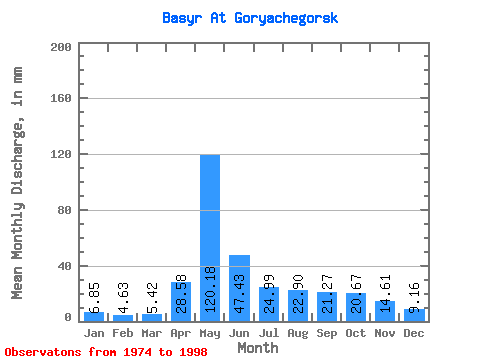
| Statistic | Jan | Feb | Mar | Apr | May | Jun | Jul | Aug | Sep | Oct | Nov | Dec | Annual |
|---|---|---|---|---|---|---|---|---|---|---|---|---|---|
| Mean | 6.85 | 4.67 | 5.42 | 28.58 | 120.16 | 47.43 | 24.99 | 22.89 | 21.28 | 20.67 | 14.62 | 9.15 | 325.53 |
| Standard Deviation | 4.24 | 2.56 | 3.19 | 17.43 | 40.86 | 17.76 | 6.47 | 12.69 | 12.09 | 8.03 | 8.38 | 4.50 | 82.42 |
| Min | 2.18 | 1.19 | 2.34 | 10.04 | 56.91 | 19.44 | 13.72 | 9.21 | 7.78 | 6.53 | 3.40 | 4.35 | 196.40 |
| Max | 19.41 | 12.66 | 17.24 | 71.28 | 192.48 | 78.73 | 33.31 | 58.92 | 44.23 | 34.98 | 34.34 | 20.09 | 501.01 |
| Coefficient of Variation | 0.62 | 0.55 | 0.59 | 0.61 | 0.34 | 0.38 | 0.26 | 0.55 | 0.57 | 0.39 | 0.57 | 0.49 | 0.25 |
 Return to R-Arctic Net Home Page