|
|
|||||||||||||||||
| Point ID: 6803 | Downloads | Plots | Site Data | Code: 10357 |
|
|
|||||||||||||||||
| Download | |
|---|---|
| Site Descriptor Information | Site Time Series Data |
| Link to all available data | |
| View: | Time Series | All |
| Units: | m3/s |
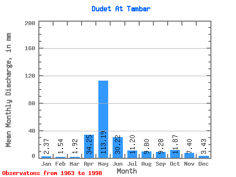
| Statistic | Jan | Feb | Mar | Apr | May | Jun | Jul | Aug | Sep | Oct | Nov | Dec | Annual |
|---|---|---|---|---|---|---|---|---|---|---|---|---|---|
| Mean | 2.37 | 1.55 | 1.92 | 34.25 | 113.18 | 30.22 | 11.20 | 9.80 | 9.28 | 11.87 | 7.40 | 3.43 | 235.22 |
| Standard Deviation | 1.37 | 1.10 | 1.14 | 19.21 | 39.32 | 23.10 | 9.53 | 7.54 | 7.90 | 6.80 | 4.33 | 1.83 | 65.64 |
| Min | 0.36 | 0.08 | 0.14 | 4.51 | 40.15 | 3.20 | 1.26 | 1.26 | 0.72 | 3.05 | 0.80 | 1.00 | 130.60 |
| Max | 6.14 | 4.01 | 4.35 | 83.45 | 192.03 | 96.52 | 40.80 | 33.14 | 30.09 | 28.83 | 17.87 | 6.58 | 376.80 |
| Coefficient of Variation | 0.58 | 0.71 | 0.59 | 0.56 | 0.35 | 0.76 | 0.85 | 0.77 | 0.85 | 0.57 | 0.58 | 0.53 | 0.28 |
 Return to R-Arctic Net Home Page