|
|
|||||||||||||||||
| Point ID: 6793 | Downloads | Plots | Site Data | Code: 10330 |
|
|
|||||||||||||||||
| Download | |
|---|---|
| Site Descriptor Information | Site Time Series Data |
| Link to all available data | |
| View: | Time Series | All |
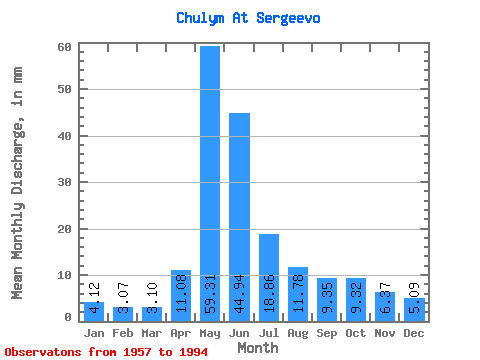
| Units: | m3/s |
| Statistic | Jan | Feb | Mar | Apr | May | Jun | Jul | Aug | Sep | Oct | Nov | Dec | Annual |
|---|---|---|---|---|---|---|---|---|---|---|---|---|---|
| Mean | 4.12 | 3.10 | 3.10 | 11.09 | 59.30 | 44.94 | 18.86 | 11.78 | 9.35 | 9.32 | 6.37 | 5.09 | 185.54 |
| Standard Deviation | 0.82 | 0.58 | 0.53 | 6.26 | 12.89 | 17.04 | 6.75 | 3.88 | 2.34 | 2.14 | 1.58 | 0.97 | 37.21 |
| Min | 2.78 | 2.06 | 2.16 | 2.76 | 29.24 | 18.17 | 8.33 | 6.26 | 5.61 | 5.87 | 3.76 | 3.49 | 118.86 |
| Max | 6.66 | 4.61 | 4.54 | 30.68 | 83.78 | 80.85 | 31.94 | 24.81 | 15.70 | 14.27 | 9.70 | 8.01 | 257.69 |
| Coefficient of Variation | 0.20 | 0.19 | 0.17 | 0.56 | 0.22 | 0.38 | 0.36 | 0.33 | 0.25 | 0.23 | 0.25 | 0.19 | 0.20 |
 Return to R-Arctic Net Home Page