|
|
|||||||||||||||||
| Point ID: 6782 | Downloads | Plots | Site Data | Code: 10301 |
|
|
|||||||||||||||||
| Download | |
|---|---|
| Site Descriptor Information | Site Time Series Data |
| Link to all available data | |
| View: | Time Series | All |
| Units: | m3/s |
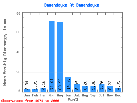
| Statistic | Jan | Feb | Mar | Apr | May | Jun | Jul | Aug | Sep | Oct | Nov | Dec | Annual |
|---|---|---|---|---|---|---|---|---|---|---|---|---|---|
| Mean | 3.35 | 2.97 | 4.17 | 71.01 | 69.94 | 14.76 | 8.09 | 6.20 | 5.96 | 7.76 | 6.23 | 4.03 | 204.49 |
| Standard Deviation | 0.97 | 0.96 | 1.52 | 37.65 | 43.78 | 10.15 | 5.13 | 3.10 | 2.68 | 3.48 | 2.52 | 1.12 | 59.61 |
| Min | 1.53 | 1.46 | 2.27 | 9.48 | 13.72 | 4.38 | 3.00 | 2.40 | 2.58 | 4.13 | 2.71 | 2.27 | 105.66 |
| Max | 6.13 | 6.19 | 8.06 | 176.67 | 169.87 | 58.67 | 22.92 | 13.59 | 13.86 | 19.39 | 12.31 | 6.46 | 339.02 |
| Coefficient of Variation | 0.29 | 0.32 | 0.37 | 0.53 | 0.63 | 0.69 | 0.63 | 0.50 | 0.45 | 0.45 | 0.41 | 0.28 | 0.29 |
 Return to R-Arctic Net Home Page