|
|
|||||||||||||||||
| Point ID: 6775 | Downloads | Plots | Site Data | Code: 10287 |
|
|
|||||||||||||||||
| Download | |
|---|---|
| Site Descriptor Information | Site Time Series Data |
| Link to all available data | |
| View: | Time Series | All |
| Units: | m3/s |
| Statistic | Jan | Feb | Mar | Apr | May | Jun | Jul | Aug | Sep | Oct | Nov | Dec | Annual |
|---|---|---|---|---|---|---|---|---|---|---|---|---|---|
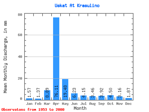
| Mean | 1.56 | 1.38 | 8.89 | 76.11 | 19.48 | 6.23 | 4.15 | 3.46 | 3.92 | 4.50 | 3.16 | 1.87 | 136.06 |
| Standard Deviation | 1.09 | 1.02 | 10.56 | 28.83 | 14.20 | 3.48 | 3.10 | 2.50 | 2.93 | 2.86 | 1.85 | 1.30 | 46.17 |
| Min | 0.15 | 0.24 | 0.20 | 19.05 | 4.56 | 1.45 | 0.36 | 0.53 | 0.68 | 1.09 | 0.49 | 0.24 | 75.08 |
| Max | 4.25 | 3.94 | 41.74 | 141.98 | 73.34 | 14.99 | 15.88 | 12.47 | 15.44 | 15.30 | 8.13 | 5.81 | 273.92 |
| Coefficient of Variation | 0.70 | 0.74 | 1.19 | 0.38 | 0.73 | 0.56 | 0.75 | 0.72 | 0.75 | 0.64 | 0.58 | 0.69 | 0.34 |
 Return to R-Arctic Net Home Page