|
|
|||||||||||||||||
| Point ID: 675 | Downloads | Plots | Site Data | Other Close Sites | Code: 07BK001 |
|
|
|||||||||||||||||
| Download | |
|---|---|
| Site Descriptor Information | Site Time Series Data |
| Link to all available data | |
| View: | Time Series | All |
| Units: | m3/s |
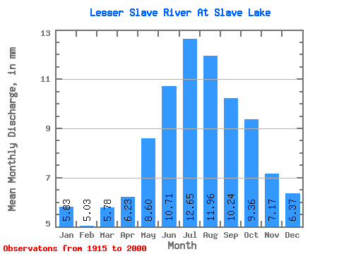
| Statistic | Jan | Feb | Mar | Apr | May | Jun | Jul | Aug | Sep | Oct | Nov | Dec | Annual |
|---|---|---|---|---|---|---|---|---|---|---|---|---|---|
| Mean | 5.66 | 4.93 | 5.61 | 6.05 | 8.34 | 10.39 | 12.27 | 11.61 | 9.94 | 9.08 | 6.96 | 6.19 | 92.37 |
| Standard Deviation | 3.87 | 3.28 | 3.42 | 3.23 | 4.08 | 5.60 | 7.65 | 7.49 | 6.59 | 6.00 | 4.89 | 4.53 | 46.11 |
| Min | 0.85 | 0.78 | 0.82 | 1.10 | 2.34 | 2.99 | 3.50 | 2.54 | 1.64 | 1.08 | 0.38 | 0.80 | 27.05 |
| Max | 19.57 | 16.47 | 16.52 | 15.23 | 20.68 | 29.73 | 43.12 | 42.14 | 34.88 | 27.57 | 22.11 | 21.86 | 233.18 |
| Coefficient of Variation | 0.68 | 0.67 | 0.61 | 0.53 | 0.49 | 0.54 | 0.62 | 0.65 | 0.66 | 0.66 | 0.70 | 0.73 | 0.50 |
| Other Close Sites | ||||||
|---|---|---|---|---|---|---|
| PointID | Latitude | Longitude | Drainage Area | Source | Name | |
| 680 | "LESSER SLAVE RIVER AT HIGHWAY NO. 2A" | 55.29 | 1581665 | Hydat | ||
 Return to R-Arctic Net Home Page