|
|
|||||||||||||||||
| Point ID: 6744 | Downloads | Plots | Site Data | Code: 10208 |
|
|
|||||||||||||||||
| Download | |
|---|---|
| Site Descriptor Information | Site Time Series Data |
| Link to all available data | |
| View: | Time Series | All |
| Units: | m3/s |
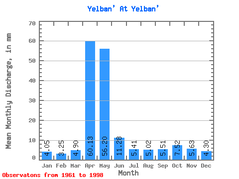
| Statistic | Jan | Feb | Mar | Apr | May | Jun | Jul | Aug | Sep | Oct | Nov | Dec | Annual |
|---|---|---|---|---|---|---|---|---|---|---|---|---|---|
| Mean | 4.04 | 3.27 | 4.89 | 60.12 | 56.19 | 11.28 | 5.41 | 5.02 | 5.51 | 7.52 | 5.63 | 4.30 | 173.85 |
| Standard Deviation | 1.40 | 0.99 | 4.07 | 41.74 | 52.03 | 15.62 | 1.74 | 1.82 | 3.08 | 2.96 | 1.76 | 1.48 | 69.21 |
| Min | 1.39 | 1.18 | 2.03 | 12.07 | 9.33 | 3.40 | 2.68 | 2.49 | 2.32 | 3.23 | 2.68 | 2.03 | 98.94 |
| Max | 7.48 | 5.05 | 27.43 | 210.04 | 233.63 | 99.21 | 9.51 | 10.25 | 17.52 | 14.22 | 10.55 | 7.02 | 404.02 |
| Coefficient of Variation | 0.34 | 0.30 | 0.83 | 0.69 | 0.93 | 1.39 | 0.32 | 0.36 | 0.56 | 0.39 | 0.31 | 0.34 | 0.40 |
 Return to R-Arctic Net Home Page