|
|
|||||||||||||||||
| Point ID: 674 | Downloads | Plots | Site Data | Code: 07BJ004 |
|
|
|||||||||||||||||
| Download | |
|---|---|
| Site Descriptor Information | Site Time Series Data |
| Link to all available data | |
| View: | Time Series | All |
| Units: | m3/s |
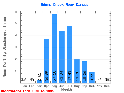
| Statistic | Jan | Feb | Mar | Apr | May | Jun | Jul | Aug | Sep | Oct | Nov | Dec | Annual |
|---|---|---|---|---|---|---|---|---|---|---|---|---|---|
| Mean | 2.63 | 36.86 | 57.26 | 43.29 | 47.48 | 19.71 | 18.27 | 8.98 | |||||
| Standard Deviation | 4.37 | 18.63 | 30.42 | 32.74 | 49.64 | 24.80 | 21.35 | 6.32 | |||||
| Min | 0.00 | 10.46 | 18.92 | 9.00 | 4.25 | 1.77 | 1.20 | 2.31 | |||||
| Max | 19.27 | 77.01 | 127.69 | 126.78 | 154.47 | 102.27 | 84.15 | 26.78 | |||||
| Coefficient of Variation | 1.66 | 0.51 | 0.53 | 0.76 | 1.05 | 1.26 | 1.17 | 0.70 |
 Return to R-Arctic Net Home Page