|
|
|||||||||||||||||
| Point ID: 6725 | Downloads | Plots | Site Data | Code: 10168 |
|
|
|||||||||||||||||
| Download | |
|---|---|
| Site Descriptor Information | Site Time Series Data |
| Link to all available data | |
| View: | Time Series | All |
| Units: | m3/s |
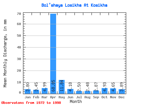
| Statistic | Jan | Feb | Mar | Apr | May | Jun | Jul | Aug | Sep | Oct | Nov | Dec | Annual |
|---|---|---|---|---|---|---|---|---|---|---|---|---|---|
| Mean | 3.80 | 3.49 | 4.99 | 68.85 | 11.84 | 4.18 | 2.50 | 2.48 | 2.87 | 4.93 | 4.66 | 3.89 | 119.01 |
| Standard Deviation | 1.25 | 1.08 | 2.00 | 22.52 | 8.73 | 1.89 | 0.65 | 0.71 | 0.83 | 1.29 | 1.15 | 1.16 | 23.99 |
| Min | 0.86 | 0.79 | 2.28 | 30.03 | 4.74 | 2.44 | 1.48 | 1.60 | 1.85 | 2.65 | 2.44 | 1.79 | 78.42 |
| Max | 6.03 | 5.50 | 11.88 | 125.73 | 49.37 | 10.67 | 3.94 | 4.25 | 4.77 | 7.33 | 6.85 | 6.83 | 178.15 |
| Coefficient of Variation | 0.33 | 0.31 | 0.40 | 0.33 | 0.74 | 0.45 | 0.26 | 0.28 | 0.29 | 0.26 | 0.25 | 0.30 | 0.20 |
 Return to R-Arctic Net Home Page