|
|
|||||||||||||||||
| Point ID: 6723 | Downloads | Plots | Site Data | Code: 10151 |
|
|
|||||||||||||||||
| Download | |
|---|---|
| Site Descriptor Information | Site Time Series Data |
| Link to all available data | |
| View: | Time Series | All |
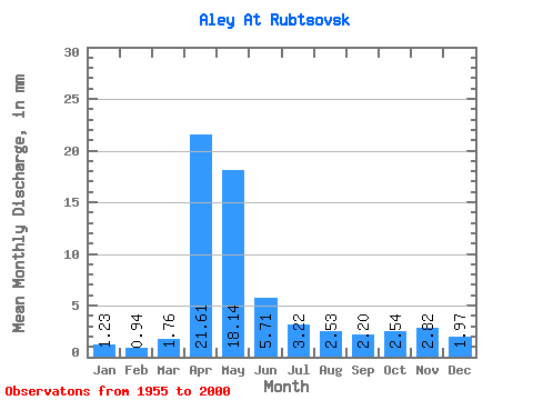
| Units: | m3/s |
| Statistic | Jan | Feb | Mar | Apr | May | Jun | Jul | Aug | Sep | Oct | Nov | Dec | Annual |
|---|---|---|---|---|---|---|---|---|---|---|---|---|---|
| Mean | 1.23 | 0.95 | 1.76 | 21.61 | 18.14 | 5.71 | 3.22 | 2.53 | 2.20 | 2.54 | 2.82 | 1.97 | 65.01 |
| Standard Deviation | 0.65 | 0.53 | 2.04 | 10.36 | 12.48 | 3.45 | 2.14 | 1.58 | 1.51 | 1.59 | 1.61 | 1.22 | 22.34 |
| Min | 0.14 | 0.09 | 0.04 | 4.96 | 1.55 | 1.03 | 0.79 | 0.69 | 0.66 | 0.66 | 0.53 | 0.24 | 25.33 |
| Max | 2.94 | 2.46 | 11.75 | 46.81 | 55.90 | 17.29 | 10.97 | 8.55 | 8.46 | 8.48 | 7.67 | 6.86 | 125.98 |
| Coefficient of Variation | 0.53 | 0.56 | 1.16 | 0.48 | 0.69 | 0.60 | 0.66 | 0.62 | 0.69 | 0.63 | 0.57 | 0.62 | 0.34 |
 Return to R-Arctic Net Home Page