|
|
|||||||||||||||||
| Point ID: 672 | Downloads | Plots | Site Data | Code: 07BJ001 |
|
|
|||||||||||||||||
| Download | |
|---|---|
| Site Descriptor Information | Site Time Series Data |
| Link to all available data | |
| View: | Time Series | All |
| Units: | m3/s |
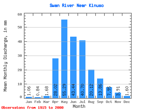
| Statistic | Jan | Feb | Mar | Apr | May | Jun | Jul | Aug | Sep | Oct | Nov | Dec | Annual |
|---|---|---|---|---|---|---|---|---|---|---|---|---|---|
| Mean | 1.06 | 0.84 | 1.68 | 28.02 | 55.29 | 43.44 | 40.70 | 20.12 | 13.87 | 7.95 | 3.91 | 1.59 | 223.51 |
| Standard Deviation | 0.65 | 0.60 | 2.06 | 16.66 | 39.41 | 31.66 | 31.63 | 20.24 | 13.78 | 5.61 | 2.02 | 0.92 | 83.09 |
| Min | 0.25 | 0.17 | 0.19 | 4.62 | 8.60 | 5.20 | 4.43 | 2.02 | 0.92 | 1.15 | 0.87 | 0.15 | 61.41 |
| Max | 2.23 | 2.29 | 12.85 | 72.58 | 235.38 | 175.98 | 140.66 | 91.05 | 58.12 | 29.32 | 8.43 | 3.33 | 450.66 |
| Coefficient of Variation | 0.61 | 0.71 | 1.23 | 0.59 | 0.71 | 0.73 | 0.78 | 1.01 | 0.99 | 0.70 | 0.52 | 0.58 | 0.37 |
 Return to R-Arctic Net Home Page