|
|
|||||||||||||||||
| Point ID: 6695 | Downloads | Plots | Site Data | Code: 10091 |
|
|
|||||||||||||||||
| Download | |
|---|---|
| Site Descriptor Information | Site Time Series Data |
| Link to all available data | |
| View: | Time Series | All |
| Units: | m3/s |
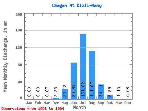
| Statistic | Jan | Feb | Mar | Apr | May | Jun | Jul | Aug | Sep | Oct | Nov | Dec | Annual |
|---|---|---|---|---|---|---|---|---|---|---|---|---|---|
| Mean | 0.00 | 0.00 | 0.07 | 3.23 | 23.12 | 84.87 | 151.80 | 111.66 | 34.11 | 8.89 | 1.10 | 0.08 | 419.70 |
| Standard Deviation | 0.00 | 0.00 | 0.21 | 3.82 | 17.08 | 41.98 | 50.39 | 36.36 | 18.53 | 4.21 | 0.89 | 0.13 | 65.43 |
| Min | 0.00 | 0.00 | 0.00 | 0.01 | 2.74 | 12.96 | 33.04 | 56.37 | 8.71 | 1.87 | 0.05 | 0.00 | 333.42 |
| Max | 0.00 | 0.00 | 0.63 | 20.76 | 68.68 | 222.27 | 258.44 | 228.21 | 75.25 | 20.45 | 2.93 | 0.36 | 527.91 |
| Coefficient of Variation | 2.85 | 1.18 | 0.74 | 0.49 | 0.33 | 0.33 | 0.54 | 0.47 | 0.81 | 1.72 | 0.16 |
 Return to R-Arctic Net Home Page