|
|
|||||||||||||||||
| Point ID: 6667 | Downloads | Plots | Site Data | Code: 10036 |
|
|
|||||||||||||||||
| Download | |
|---|---|
| Site Descriptor Information | Site Time Series Data |
| Link to all available data | |
| View: | Time Series | All |
| Units: | m3/s |
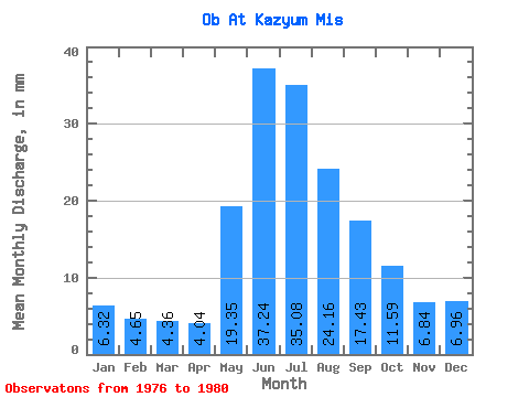
| Statistic | Jan | Feb | Mar | Apr | May | Jun | Jul | Aug | Sep | Oct | Nov | Dec | Annual |
|---|---|---|---|---|---|---|---|---|---|---|---|---|---|
| Mean | 5.17 | 3.84 | 3.57 | 3.31 | 15.84 | 30.49 | 28.72 | 19.78 | 14.27 | 9.49 | 5.60 | 5.70 | 145.28 |
| Standard Deviation | 1.10 | 0.59 | 0.30 | 0.26 | 4.40 | 4.34 | 7.55 | 12.45 | 9.04 | 2.67 | 1.54 | 1.03 | 33.65 |
| Min | 4.09 | 3.23 | 3.25 | 3.09 | 9.89 | 24.93 | 18.57 | 8.95 | 7.58 | 6.31 | 4.32 | 4.58 | 113.06 |
| Max | 6.47 | 4.56 | 3.99 | 3.67 | 22.21 | 36.40 | 37.60 | 40.50 | 29.89 | 11.76 | 8.14 | 7.01 | 199.79 |
| Coefficient of Variation | 0.21 | 0.15 | 0.08 | 0.08 | 0.28 | 0.14 | 0.26 | 0.63 | 0.63 | 0.28 | 0.28 | 0.18 | 0.23 |
 Return to R-Arctic Net Home Page