|
|
|||||||||||||||||
| Point ID: 6652 | Downloads | Plots | Site Data | Code: 9536 |
|
|
|||||||||||||||||
| Download | |
|---|---|
| Site Descriptor Information | Site Time Series Data |
| Link to all available data | |
| View: | Time Series | All |
| Units: | m3/s |
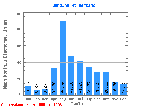
| Statistic | Jan | Feb | Mar | Apr | May | Jun | Jul | Aug | Sep | Oct | Nov | Dec | Annual |
|---|---|---|---|---|---|---|---|---|---|---|---|---|---|
| Mean | 10.97 | 6.93 | 8.27 | 32.70 | 90.34 | 47.68 | 41.24 | 34.77 | 28.92 | 28.32 | 16.76 | 14.33 | 339.88 |
| Standard Deviation | 4.58 | 3.54 | 4.10 | 21.42 | 23.01 | 12.71 | 15.86 | 16.49 | 12.43 | 10.14 | 6.41 | 6.29 | 73.69 |
| Min | 4.34 | 0.00 | 0.00 | 6.21 | 41.44 | 24.22 | 22.68 | 17.26 | 15.72 | 16.18 | 7.13 | 4.85 | 217.25 |
| Max | 20.52 | 10.76 | 13.72 | 77.38 | 121.19 | 63.95 | 72.91 | 68.22 | 55.62 | 49.06 | 24.79 | 25.02 | 423.56 |
| Coefficient of Variation | 0.42 | 0.51 | 0.50 | 0.66 | 0.26 | 0.27 | 0.39 | 0.47 | 0.43 | 0.36 | 0.38 | 0.44 | 0.22 |
 Return to R-Arctic Net Home Page