|
|
|||||||||||||||||
| Point ID: 6650 | Downloads | Plots | Site Data | Code: 9520 |
|
|
|||||||||||||||||
| Download | |
|---|---|
| Site Descriptor Information | Site Time Series Data |
| Link to all available data | |
| View: | Time Series | All |
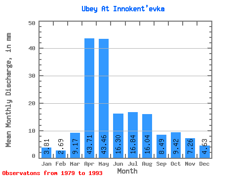
| Units: | m3/s |
| Statistic | Jan | Feb | Mar | Apr | May | Jun | Jul | Aug | Sep | Oct | Nov | Dec | Annual |
|---|---|---|---|---|---|---|---|---|---|---|---|---|---|
| Mean | 3.80 | 2.71 | 9.17 | 43.72 | 43.45 | 16.30 | 16.83 | 16.04 | 8.49 | 9.42 | 7.25 | 4.62 | 173.29 |
| Standard Deviation | 2.15 | 2.51 | 15.97 | 22.56 | 18.56 | 7.38 | 15.81 | 20.43 | 3.60 | 3.70 | 3.25 | 2.01 | 57.95 |
| Min | 0.00 | 0.00 | 0.00 | 16.54 | 11.28 | 6.48 | 6.08 | 4.23 | 4.52 | 4.76 | 3.92 | 0.88 | 109.70 |
| Max | 8.37 | 8.83 | 50.74 | 84.67 | 73.64 | 31.80 | 53.65 | 78.93 | 16.37 | 18.50 | 16.03 | 6.78 | 299.16 |
| Coefficient of Variation | 0.56 | 0.93 | 1.74 | 0.52 | 0.43 | 0.45 | 0.94 | 1.27 | 0.42 | 0.39 | 0.45 | 0.43 | 0.33 |
 Return to R-Arctic Net Home Page