|
|
|||||||||||||||||
| Point ID: 6642 | Downloads | Plots | Site Data | Code: 9499 |
|
|
|||||||||||||||||
| Download | |
|---|---|
| Site Descriptor Information | Site Time Series Data |
| Link to all available data | |
| View: | Time Series | All |
| Units: | m3/s |
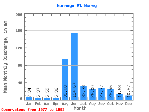
| Statistic | Jan | Feb | Mar | Apr | May | Jun | Jul | Aug | Sep | Oct | Nov | Dec | Annual |
|---|---|---|---|---|---|---|---|---|---|---|---|---|---|
| Mean | 7.34 | 5.42 | 5.59 | 5.36 | 95.06 | 154.68 | 32.78 | 25.99 | 27.77 | 25.96 | 14.63 | 10.57 | 409.28 |
| Standard Deviation | 3.89 | 2.57 | 2.54 | 1.72 | 49.36 | 67.62 | 10.81 | 10.08 | 11.55 | 12.11 | 6.09 | 4.50 | 70.67 |
| Min | 2.57 | 1.00 | 0.90 | 2.22 | 12.11 | 73.20 | 17.72 | 16.95 | 13.04 | 8.10 | 3.98 | 4.26 | 321.09 |
| Max | 17.31 | 11.40 | 9.45 | 8.85 | 175.68 | 294.45 | 52.49 | 51.85 | 51.63 | 46.70 | 24.88 | 18.70 | 538.06 |
| Coefficient of Variation | 0.53 | 0.47 | 0.45 | 0.32 | 0.52 | 0.44 | 0.33 | 0.39 | 0.42 | 0.47 | 0.42 | 0.43 | 0.17 |
 Return to R-Arctic Net Home Page