|
|
|||||||||||||||||
| Point ID: 6633 | Downloads | Plots | Site Data | Code: 9427 |
|
|
|||||||||||||||||
| Download | |
|---|---|
| Site Descriptor Information | Site Time Series Data |
| Link to all available data | |
| View: | Time Series | All |
| Units: | m3/s |
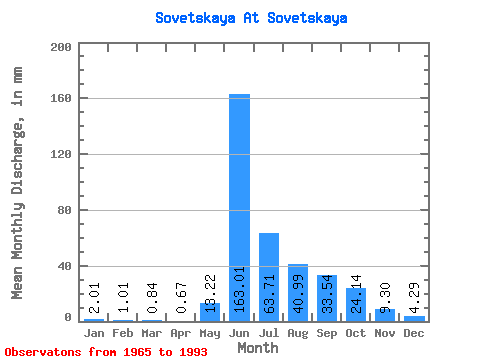
| Statistic | Jan | Feb | Mar | Apr | May | Jun | Jul | Aug | Sep | Oct | Nov | Dec | Annual |
|---|---|---|---|---|---|---|---|---|---|---|---|---|---|
| Mean | 2.01 | 1.02 | 0.84 | 0.67 | 13.22 | 163.01 | 63.70 | 40.98 | 33.54 | 24.14 | 9.30 | 4.29 | 353.14 |
| Standard Deviation | 1.19 | 0.93 | 0.85 | 0.68 | 17.43 | 41.19 | 13.57 | 14.63 | 11.87 | 10.63 | 4.87 | 2.49 | 62.94 |
| Min | 0.51 | 0.11 | 0.15 | 0.07 | 0.69 | 95.16 | 43.63 | 23.78 | 16.31 | 11.33 | 2.96 | 1.07 | 274.44 |
| Max | 4.70 | 3.57 | 3.24 | 2.52 | 54.50 | 253.76 | 106.56 | 80.34 | 62.35 | 47.01 | 21.03 | 9.44 | 458.57 |
| Coefficient of Variation | 0.59 | 0.91 | 1.02 | 1.01 | 1.32 | 0.25 | 0.21 | 0.36 | 0.35 | 0.44 | 0.52 | 0.58 | 0.18 |
 Return to R-Arctic Net Home Page