|
|
|||||||||||||||||
| Point ID: 6626 | Downloads | Plots | Site Data | Code: 9415 |
|
|
|||||||||||||||||
| Download | |
|---|---|
| Site Descriptor Information | Site Time Series Data |
| Link to all available data | |
| View: | Time Series | All |
| Units: | m3/s |
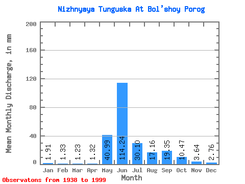
| Statistic | Jan | Feb | Mar | Apr | May | Jun | Jul | Aug | Sep | Oct | Nov | Dec | Annual |
|---|---|---|---|---|---|---|---|---|---|---|---|---|---|
| Mean | 1.91 | 1.34 | 1.23 | 1.32 | 40.98 | 114.24 | 30.10 | 17.16 | 19.36 | 10.47 | 3.64 | 2.77 | 246.42 |
| Standard Deviation | 0.73 | 0.55 | 0.51 | 1.21 | 24.71 | 30.32 | 11.28 | 8.98 | 8.10 | 4.69 | 1.27 | 0.92 | 31.82 |
| Min | 0.52 | 0.24 | 0.17 | 0.21 | 4.23 | 53.46 | 14.80 | 4.82 | 4.69 | 3.60 | 1.44 | 1.20 | 202.00 |
| Max | 5.19 | 3.89 | 3.34 | 9.45 | 113.83 | 182.66 | 59.91 | 55.48 | 41.05 | 23.84 | 8.41 | 6.11 | 331.16 |
| Coefficient of Variation | 0.38 | 0.41 | 0.41 | 0.92 | 0.60 | 0.27 | 0.38 | 0.52 | 0.42 | 0.45 | 0.35 | 0.33 | 0.13 |
 Return to R-Arctic Net Home Page