|
|
|||||||||||||||||
| Point ID: 6622 | Downloads | Plots | Site Data | Code: 9404 |
|
|
|||||||||||||||||
| Download | |
|---|---|
| Site Descriptor Information | Site Time Series Data |
| Link to all available data | |
| View: | Time Series | All |
| Units: | m3/s |
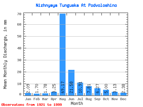
| Statistic | Jan | Feb | Mar | Apr | May | Jun | Jul | Aug | Sep | Oct | Nov | Dec | Annual |
|---|---|---|---|---|---|---|---|---|---|---|---|---|---|
| Mean | 2.09 | 1.71 | 1.78 | 3.25 | 69.16 | 21.58 | 10.91 | 7.81 | 6.27 | 5.00 | 3.13 | 2.38 | 134.48 |
| Standard Deviation | 0.84 | 0.78 | 0.84 | 3.77 | 20.32 | 9.47 | 6.87 | 4.82 | 2.74 | 2.28 | 1.20 | 0.90 | 34.75 |
| Min | 0.26 | 0.13 | 0.14 | 0.45 | 17.20 | 6.86 | 2.85 | 2.34 | 2.32 | 1.48 | 1.01 | 0.55 | 49.42 |
| Max | 4.14 | 3.90 | 3.95 | 25.73 | 113.34 | 45.76 | 38.53 | 28.89 | 16.52 | 15.45 | 6.64 | 4.73 | 244.32 |
| Coefficient of Variation | 0.40 | 0.46 | 0.47 | 1.16 | 0.29 | 0.44 | 0.63 | 0.62 | 0.44 | 0.46 | 0.38 | 0.38 | 0.26 |
 Return to R-Arctic Net Home Page