|
|
|||||||||||||||||
| Point ID: 6603 | Downloads | Plots | Site Data | Code: 9367 |
|
|
|||||||||||||||||
| Download | |
|---|---|
| Site Descriptor Information | Site Time Series Data |
| Link to all available data | |
| View: | Time Series | All |
| Units: | m3/s |
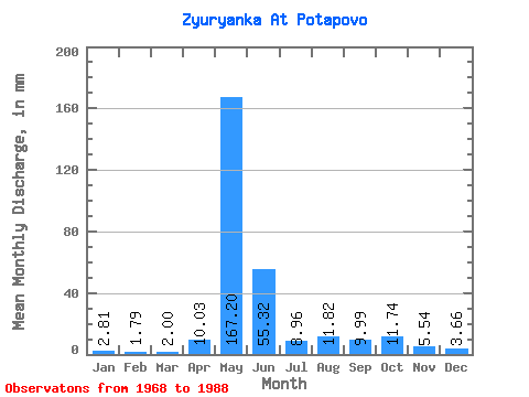
| Statistic | Jan | Feb | Mar | Apr | May | Jun | Jul | Aug | Sep | Oct | Nov | Dec | Annual |
|---|---|---|---|---|---|---|---|---|---|---|---|---|---|
| Mean | 2.81 | 1.80 | 2.00 | 10.03 | 167.17 | 55.32 | 8.95 | 11.82 | 9.99 | 11.74 | 5.54 | 3.66 | 288.53 |
| Standard Deviation | 0.76 | 0.61 | 0.70 | 13.03 | 41.15 | 34.79 | 2.51 | 11.08 | 5.37 | 8.21 | 2.92 | 0.94 | 58.29 |
| Min | 1.05 | 0.71 | 1.05 | 1.12 | 53.87 | 19.02 | 5.97 | 3.76 | 3.08 | 3.29 | 2.48 | 1.43 | 163.97 |
| Max | 4.26 | 2.97 | 3.29 | 53.27 | 225.17 | 162.42 | 14.65 | 51.93 | 22.32 | 38.72 | 16.43 | 5.66 | 370.41 |
| Coefficient of Variation | 0.27 | 0.34 | 0.35 | 1.30 | 0.25 | 0.63 | 0.28 | 0.94 | 0.54 | 0.70 | 0.53 | 0.26 | 0.20 |
 Return to R-Arctic Net Home Page