|
|
|||||||||||||||||
| Point ID: 6584 | Downloads | Plots | Site Data | Code: 9286 |
|
|
|||||||||||||||||
| Download | |
|---|---|
| Site Descriptor Information | Site Time Series Data |
| Link to all available data | |
| View: | Time Series | All |
| Units: | m3/s |
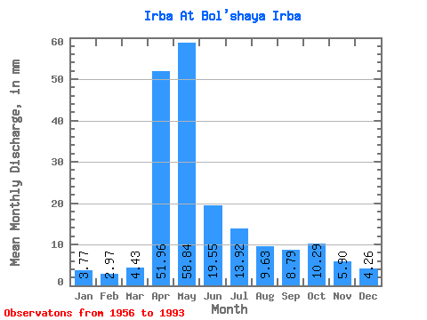
| Statistic | Jan | Feb | Mar | Apr | May | Jun | Jul | Aug | Sep | Oct | Nov | Dec | Annual |
|---|---|---|---|---|---|---|---|---|---|---|---|---|---|
| Mean | 3.77 | 3.00 | 4.42 | 51.96 | 58.83 | 19.54 | 13.92 | 9.63 | 8.80 | 10.29 | 5.90 | 4.26 | 193.91 |
| Standard Deviation | 0.72 | 0.78 | 1.96 | 19.99 | 34.67 | 10.52 | 14.45 | 5.83 | 4.62 | 4.28 | 2.33 | 0.96 | 49.32 |
| Min | 2.05 | 1.49 | 1.50 | 21.69 | 15.30 | 6.74 | 4.51 | 3.83 | 4.36 | 4.65 | 3.04 | 2.46 | 127.88 |
| Max | 5.05 | 5.23 | 12.57 | 99.84 | 202.22 | 47.34 | 84.99 | 28.15 | 26.85 | 19.40 | 11.51 | 6.97 | 320.70 |
| Coefficient of Variation | 0.19 | 0.26 | 0.44 | 0.39 | 0.59 | 0.54 | 1.04 | 0.60 | 0.53 | 0.42 | 0.40 | 0.23 | 0.25 |
 Return to R-Arctic Net Home Page