|
|
|||||||||||||||||
| Point ID: 6564 | Downloads | Plots | Site Data | Code: 9170 |
|
|
|||||||||||||||||
| Download | |
|---|---|
| Site Descriptor Information | Site Time Series Data |
| Link to all available data | |
| View: | Time Series | All |
| Units: | m3/s |
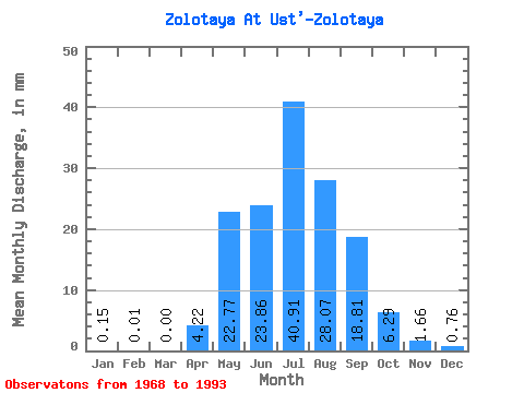
| Statistic | Jan | Feb | Mar | Apr | May | Jun | Jul | Aug | Sep | Oct | Nov | Dec | Annual |
|---|---|---|---|---|---|---|---|---|---|---|---|---|---|
| Mean | 0.15 | 0.00 | 0.00 | 4.22 | 22.77 | 23.86 | 40.90 | 28.07 | 18.81 | 6.29 | 1.65 | 0.77 | 148.75 |
| Standard Deviation | 0.10 | 0.01 | 0.00 | 3.63 | 13.09 | 14.56 | 33.91 | 17.39 | 11.51 | 2.98 | 0.81 | 1.11 | 80.43 |
| Min | 0.01 | 0.00 | 0.00 | 0.49 | 5.68 | 5.90 | 5.96 | 10.23 | 5.02 | 3.08 | 0.59 | 0.07 | 79.84 |
| Max | 0.33 | 0.01 | 0.00 | 14.18 | 53.70 | 61.54 | 149.32 | 84.83 | 46.75 | 13.74 | 3.87 | 5.61 | 285.73 |
| Coefficient of Variation | 0.64 | 1.49 | 0.86 | 0.57 | 0.61 | 0.83 | 0.62 | 0.61 | 0.47 | 0.49 | 1.45 | 0.54 |
 Return to R-Arctic Net Home Page