|
|
|||||||||||||||||
| Point ID: 6563 | Downloads | Plots | Site Data | Code: 9166 |
|
|
|||||||||||||||||
| Download | |
|---|---|
| Site Descriptor Information | Site Time Series Data |
| Link to all available data | |
| View: | Time Series | All |
| Units: | m3/s |
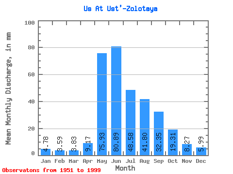
| Statistic | Jan | Feb | Mar | Apr | May | Jun | Jul | Aug | Sep | Oct | Nov | Dec | Annual |
|---|---|---|---|---|---|---|---|---|---|---|---|---|---|
| Mean | 4.78 | 3.62 | 3.83 | 9.17 | 75.92 | 80.89 | 48.57 | 41.80 | 32.35 | 19.31 | 8.27 | 5.99 | 333.12 |
| Standard Deviation | 1.04 | 0.72 | 0.67 | 4.71 | 25.18 | 32.87 | 19.56 | 16.76 | 10.89 | 5.13 | 2.07 | 1.36 | 60.79 |
| Min | 2.29 | 2.05 | 2.10 | 2.63 | 14.20 | 36.36 | 21.26 | 18.15 | 14.00 | 11.35 | 5.13 | 3.11 | 200.48 |
| Max | 7.45 | 5.19 | 5.26 | 24.14 | 126.67 | 196.41 | 132.37 | 85.03 | 57.27 | 39.36 | 14.34 | 10.91 | 454.82 |
| Coefficient of Variation | 0.22 | 0.20 | 0.17 | 0.51 | 0.33 | 0.41 | 0.40 | 0.40 | 0.34 | 0.27 | 0.25 | 0.23 | 0.18 |
 Return to R-Arctic Net Home Page