|
|
|||||||||||||||||
| Point ID: 6552 | Downloads | Plots | Site Data | Code: 9122 |
|
|
|||||||||||||||||
| Download | |
|---|---|
| Site Descriptor Information | Site Time Series Data |
| Link to all available data | |
| View: | Time Series | All |
| Units: | m3/s |
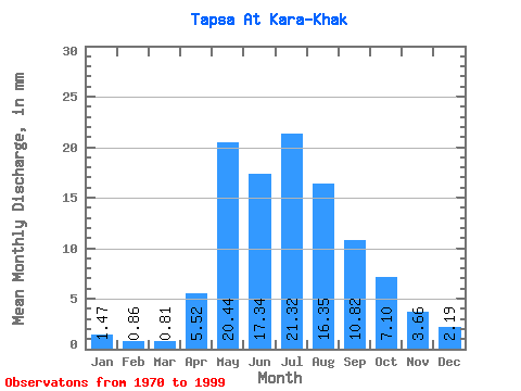
| Statistic | Jan | Feb | Mar | Apr | May | Jun | Jul | Aug | Sep | Oct | Nov | Dec | Annual |
|---|---|---|---|---|---|---|---|---|---|---|---|---|---|
| Mean | 1.46 | 0.87 | 0.81 | 5.52 | 20.44 | 17.34 | 21.32 | 16.34 | 10.81 | 7.10 | 3.66 | 2.19 | 107.24 |
| Standard Deviation | 0.78 | 0.61 | 0.67 | 2.58 | 9.92 | 8.40 | 14.44 | 10.81 | 6.03 | 3.28 | 1.75 | 0.88 | 43.74 |
| Min | 0.00 | 0.00 | 0.00 | 1.82 | 4.07 | 2.99 | 7.00 | 3.62 | 2.92 | 1.44 | 0.24 | 0.01 | 25.36 |
| Max | 2.88 | 1.92 | 2.08 | 12.83 | 40.97 | 35.67 | 59.05 | 51.96 | 26.14 | 14.08 | 8.46 | 3.78 | 218.09 |
| Coefficient of Variation | 0.54 | 0.70 | 0.83 | 0.47 | 0.48 | 0.48 | 0.68 | 0.66 | 0.56 | 0.46 | 0.48 | 0.40 | 0.41 |
 Return to R-Arctic Net Home Page