|
|
|||||||||||||||||
| Point ID: 6535 | Downloads | Plots | Site Data | Code: 8393 |
|
|
|||||||||||||||||
| Download | |
|---|---|
| Site Descriptor Information | Site Time Series Data |
| Link to all available data | |
| View: | Time Series | All |
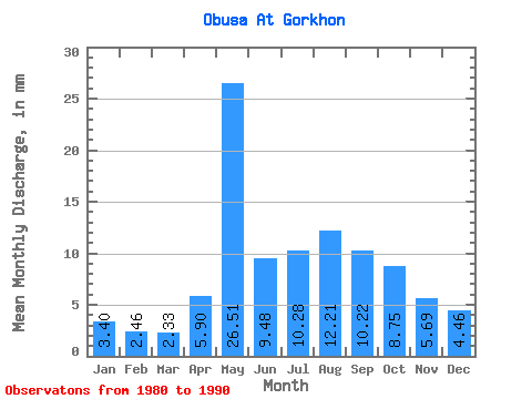
| Units: | m3/s |
| Statistic | Jan | Feb | Mar | Apr | May | Jun | Jul | Aug | Sep | Oct | Nov | Dec | Annual |
|---|---|---|---|---|---|---|---|---|---|---|---|---|---|
| Mean | 3.40 | 2.48 | 2.33 | 5.90 | 26.51 | 9.48 | 10.28 | 12.21 | 10.22 | 8.75 | 5.69 | 4.46 | 102.47 |
| Standard Deviation | 1.89 | 1.06 | 1.06 | 4.06 | 13.95 | 3.97 | 4.47 | 5.87 | 4.29 | 4.13 | 2.42 | 1.94 | 38.01 |
| Min | 0.10 | 1.35 | 0.46 | 1.07 | 8.56 | 3.30 | 3.70 | 4.80 | 4.73 | 3.78 | 3.08 | 2.39 | 48.55 |
| Max | 7.39 | 4.95 | 4.24 | 16.01 | 50.32 | 17.00 | 17.63 | 22.57 | 17.55 | 18.48 | 12.00 | 9.55 | 164.89 |
| Coefficient of Variation | 0.55 | 0.43 | 0.45 | 0.69 | 0.53 | 0.42 | 0.43 | 0.48 | 0.42 | 0.47 | 0.42 | 0.43 | 0.37 |
 Return to R-Arctic Net Home Page