|
|
|||||||||||||||||
| Point ID: 6527 | Downloads | Plots | Site Data | Code: 8370 |
|
|
|||||||||||||||||
| Download | |
|---|---|
| Site Descriptor Information | Site Time Series Data |
| Link to all available data | |
| View: | Time Series | All |
| Units: | m3/s |
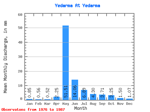
| Statistic | Jan | Feb | Mar | Apr | May | Jun | Jul | Aug | Sep | Oct | Nov | Dec | Annual |
|---|---|---|---|---|---|---|---|---|---|---|---|---|---|
| Mean | 0.85 | 0.56 | 0.52 | 2.25 | 51.51 | 14.06 | 6.89 | 4.30 | 3.71 | 3.25 | 1.50 | 1.07 | 89.65 |
| Standard Deviation | 0.47 | 0.29 | 0.29 | 2.86 | 21.27 | 10.12 | 5.91 | 1.52 | 1.17 | 1.22 | 0.73 | 0.60 | 31.55 |
| Min | 0.41 | 0.25 | 0.25 | 0.34 | 16.91 | 4.58 | 2.93 | 2.72 | 1.90 | 1.99 | 0.00 | 0.00 | 47.93 |
| Max | 2.12 | 1.17 | 1.19 | 9.04 | 86.24 | 41.74 | 23.26 | 6.93 | 6.17 | 5.46 | 2.96 | 2.55 | 164.00 |
| Coefficient of Variation | 0.56 | 0.52 | 0.55 | 1.27 | 0.41 | 0.72 | 0.86 | 0.35 | 0.31 | 0.37 | 0.49 | 0.57 | 0.35 |
 Return to R-Arctic Net Home Page