|
|
|||||||||||||||||
| Point ID: 6504 | Downloads | Plots | Site Data | Code: 8309 |
|
|
|||||||||||||||||
| Download | |
|---|---|
| Site Descriptor Information | Site Time Series Data |
| Link to all available data | |
| View: | Time Series | All |
| Units: | m3/s |
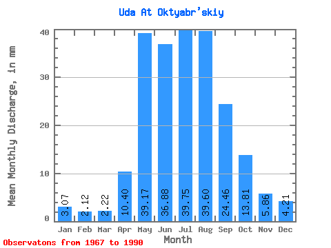
| Statistic | Jan | Feb | Mar | Apr | May | Jun | Jul | Aug | Sep | Oct | Nov | Dec | Annual |
|---|---|---|---|---|---|---|---|---|---|---|---|---|---|
| Mean | 3.07 | 2.14 | 2.22 | 10.40 | 39.16 | 36.88 | 39.74 | 39.59 | 24.46 | 13.81 | 5.86 | 4.21 | 217.94 |
| Standard Deviation | 0.70 | 0.51 | 0.58 | 6.29 | 11.90 | 9.41 | 15.06 | 15.38 | 7.78 | 3.23 | 1.34 | 0.74 | 39.83 |
| Min | 1.39 | 1.22 | 1.43 | 3.50 | 21.63 | 20.85 | 20.53 | 20.95 | 13.08 | 8.87 | 3.89 | 2.94 | 163.55 |
| Max | 4.46 | 3.06 | 3.46 | 25.10 | 57.02 | 64.60 | 75.61 | 84.48 | 43.26 | 22.64 | 8.99 | 5.74 | 291.81 |
| Coefficient of Variation | 0.23 | 0.24 | 0.26 | 0.60 | 0.30 | 0.26 | 0.38 | 0.39 | 0.32 | 0.23 | 0.23 | 0.17 | 0.18 |
 Return to R-Arctic Net Home Page