|
|
|||||||||||||||||
| Point ID: 650 | Downloads | Plots | Site Data | Code: 07BB009 |
|
|
|||||||||||||||||
| Download | |
|---|---|
| Site Descriptor Information | Site Time Series Data |
| Link to all available data | |
| View: | Time Series | All |
| Units: | m3/s |
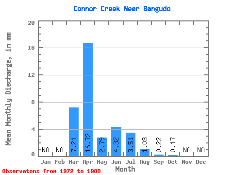
| Statistic | Jan | Feb | Mar | Apr | May | Jun | Jul | Aug | Sep | Oct | Nov | Dec | Annual |
|---|---|---|---|---|---|---|---|---|---|---|---|---|---|
| Mean | 7.07 | 16.42 | 2.75 | 4.24 | 3.44 | 1.00 | 0.21 | 0.17 | |||||
| Standard Deviation | 10.18 | 14.32 | 2.48 | 4.46 | 3.98 | 1.63 | 0.37 | 0.44 | |||||
| Min | 0.00 | 0.24 | 0.16 | 0.25 | 0.07 | 0.00 | 0.00 | 0.00 | |||||
| Max | 27.59 | 46.50 | 7.27 | 11.72 | 10.44 | 5.58 | 1.16 | 1.48 | |||||
| Coefficient of Variation | 1.44 | 0.87 | 0.90 | 1.05 | 1.16 | 1.63 | 1.74 | 2.66 |
 Return to R-Arctic Net Home Page