|
|
|||||||||||||||||
| Point ID: 6494 | Downloads | Plots | Site Data | Code: 8284 |
|
|
|||||||||||||||||
| Download | |
|---|---|
| Site Descriptor Information | Site Time Series Data |
| Link to all available data | |
| View: | Time Series | All |
| Units: | m3/s |
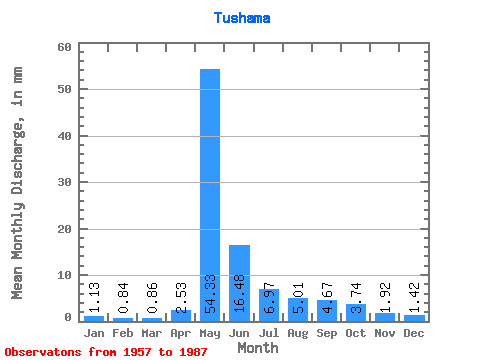
| Statistic | Jan | Feb | Mar | Apr | May | Jun | Jul | Aug | Sep | Oct | Nov | Dec | Annual |
|---|---|---|---|---|---|---|---|---|---|---|---|---|---|
| Mean | 1.13 | 0.85 | 0.86 | 2.53 | 54.32 | 16.48 | 6.97 | 5.01 | 4.67 | 3.74 | 1.93 | 1.42 | 100.69 |
| Standard Deviation | 0.49 | 0.43 | 0.47 | 2.73 | 18.31 | 9.47 | 3.68 | 2.29 | 2.13 | 1.57 | 0.70 | 0.51 | 27.85 |
| Min | 0.32 | 0.23 | 0.16 | 0.41 | 13.55 | 5.91 | 2.80 | 2.46 | 2.15 | 1.55 | 0.90 | 0.63 | 54.75 |
| Max | 2.12 | 1.98 | 2.29 | 10.74 | 90.32 | 46.93 | 19.81 | 11.57 | 10.20 | 8.00 | 3.50 | 2.54 | 172.89 |
| Coefficient of Variation | 0.43 | 0.51 | 0.55 | 1.08 | 0.34 | 0.57 | 0.53 | 0.46 | 0.46 | 0.42 | 0.36 | 0.35 | 0.28 |
 Return to R-Arctic Net Home Page