|
|
|||||||||||||||||
| Point ID: 6491 | Downloads | Plots | Site Data | Code: 8259 |
|
|
|||||||||||||||||
| Download | |
|---|---|
| Site Descriptor Information | Site Time Series Data |
| Link to all available data | |
| View: | Time Series | All |
| Units: | m3/s |
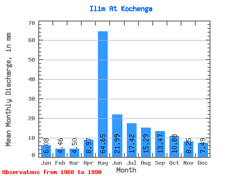
| Statistic | Jan | Feb | Mar | Apr | May | Jun | Jul | Aug | Sep | Oct | Nov | Dec | Annual |
|---|---|---|---|---|---|---|---|---|---|---|---|---|---|
| Mean | 6.08 | 4.50 | 4.50 | 8.97 | 64.64 | 21.99 | 17.42 | 15.29 | 13.47 | 10.88 | 8.25 | 7.49 | 181.83 |
| Standard Deviation | 2.19 | 1.48 | 1.33 | 5.65 | 20.75 | 8.84 | 8.04 | 7.04 | 5.84 | 4.79 | 3.51 | 2.92 | 38.44 |
| Min | 3.59 | 2.85 | 2.56 | 3.33 | 19.68 | 9.51 | 8.42 | 7.65 | 6.71 | 6.05 | 4.51 | 4.11 | 99.40 |
| Max | 13.18 | 9.15 | 8.51 | 25.69 | 102.10 | 43.28 | 36.58 | 39.69 | 28.70 | 26.30 | 20.97 | 17.57 | 283.08 |
| Coefficient of Variation | 0.36 | 0.33 | 0.30 | 0.63 | 0.32 | 0.40 | 0.46 | 0.46 | 0.43 | 0.44 | 0.42 | 0.39 | 0.21 |
 Return to R-Arctic Net Home Page