|
|
|||||||||||||||||
| Point ID: 6490 | Downloads | Plots | Site Data | Code: 8256 |
|
|
|||||||||||||||||
| Download | |
|---|---|
| Site Descriptor Information | Site Time Series Data |
| Link to all available data | |
| View: | Time Series | All |
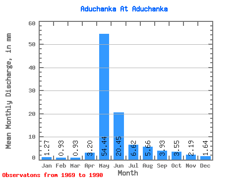
| Units: | m3/s |
| Statistic | Jan | Feb | Mar | Apr | May | Jun | Jul | Aug | Sep | Oct | Nov | Dec | Annual |
|---|---|---|---|---|---|---|---|---|---|---|---|---|---|
| Mean | 1.27 | 0.94 | 0.93 | 3.20 | 54.43 | 20.44 | 6.62 | 5.66 | 3.93 | 3.55 | 2.19 | 1.64 | 103.77 |
| Standard Deviation | 0.52 | 0.42 | 0.40 | 3.34 | 23.41 | 11.54 | 3.89 | 8.94 | 1.67 | 1.29 | 0.70 | 0.59 | 37.44 |
| Min | 0.52 | 0.39 | 0.37 | 0.84 | 17.20 | 6.96 | 2.47 | 1.12 | 1.36 | 1.14 | 0.60 | 0.58 | 49.42 |
| Max | 2.93 | 2.32 | 2.18 | 12.96 | 111.36 | 52.59 | 19.15 | 44.89 | 7.14 | 6.82 | 3.64 | 3.14 | 192.84 |
| Coefficient of Variation | 0.41 | 0.45 | 0.43 | 1.04 | 0.43 | 0.56 | 0.59 | 1.58 | 0.42 | 0.36 | 0.32 | 0.36 | 0.36 |
 Return to R-Arctic Net Home Page