|
|
|||||||||||||||||
| Point ID: 6477 | Downloads | Plots | Site Data | Code: 8198 |
|
|
|||||||||||||||||
| Download | |
|---|---|
| Site Descriptor Information | Site Time Series Data |
| Link to all available data | |
| View: | Time Series | All |
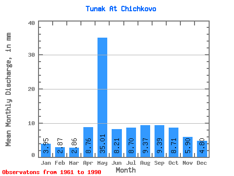
| Units: | m3/s |
| Statistic | Jan | Feb | Mar | Apr | May | Jun | Jul | Aug | Sep | Oct | Nov | Dec | Annual |
|---|---|---|---|---|---|---|---|---|---|---|---|---|---|
| Mean | 3.96 | 2.90 | 2.86 | 8.76 | 35.01 | 8.21 | 8.70 | 9.37 | 9.39 | 8.71 | 5.90 | 4.80 | 108.11 |
| Standard Deviation | 1.90 | 1.28 | 1.14 | 6.75 | 17.16 | 2.00 | 4.80 | 5.84 | 6.22 | 5.42 | 3.35 | 2.37 | 34.77 |
| Min | 1.68 | 1.05 | 0.86 | 2.52 | 9.00 | 4.41 | 3.66 | 3.66 | 3.58 | 3.66 | 2.33 | 1.65 | 50.72 |
| Max | 10.06 | 5.92 | 5.80 | 31.70 | 70.58 | 12.80 | 24.83 | 30.64 | 30.36 | 28.46 | 18.29 | 11.11 | 189.96 |
| Coefficient of Variation | 0.48 | 0.44 | 0.40 | 0.77 | 0.49 | 0.24 | 0.55 | 0.62 | 0.66 | 0.62 | 0.57 | 0.49 | 0.32 |
 Return to R-Arctic Net Home Page