|
|
|||||||||||||||||
| Point ID: 6473 | Downloads | Plots | Site Data | Code: 8182 |
|
|
|||||||||||||||||
| Download | |
|---|---|
| Site Descriptor Information | Site Time Series Data |
| Link to all available data | |
| View: | Time Series | All |
| Units: | m3/s |
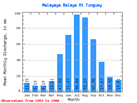
| Statistic | Jan | Feb | Mar | Apr | May | Jun | Jul | Aug | Sep | Oct | Nov | Dec | Annual |
|---|---|---|---|---|---|---|---|---|---|---|---|---|---|
| Mean | 11.15 | 8.20 | 8.19 | 13.61 | 47.55 | 71.47 | 96.82 | 93.36 | 65.96 | 37.66 | 18.93 | 14.81 | 485.28 |
| Standard Deviation | 2.31 | 1.76 | 1.49 | 4.01 | 10.34 | 15.55 | 33.19 | 22.78 | 17.27 | 7.83 | 4.80 | 3.09 | 68.21 |
| Min | 6.98 | 5.34 | 5.81 | 8.12 | 22.08 | 48.92 | 47.65 | 53.76 | 35.27 | 20.61 | 11.11 | 8.93 | 353.06 |
| Max | 17.72 | 13.09 | 11.48 | 22.74 | 73.16 | 110.44 | 183.23 | 146.99 | 111.09 | 51.68 | 29.23 | 22.35 | 602.07 |
| Coefficient of Variation | 0.21 | 0.21 | 0.18 | 0.29 | 0.22 | 0.22 | 0.34 | 0.24 | 0.26 | 0.21 | 0.25 | 0.21 | 0.14 |
 Return to R-Arctic Net Home Page